
In the beginning there was simply a big agricultural field. That is in the 19th and most of the 20th century. Then a long narrow strip lying parallel to the road was partitioned off from the larger field. Mostly it was used as pasture or for potato growing when it was the property of the Herrison Hospital community which grew most of its own food. A map from the early 1940’s called the place Clover Ground. Then, shortly after the village was developed from the the former hospital site in the late 1990’s, an area called The Swale was created to take rainwater run-off from the village streets, via culverts under the road, to a down-slope soak-away area. This drainage area lies on the western side of the field strip alongside the road.
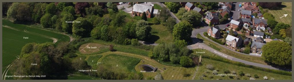
The remainder of the rectilinear strip was designated by the Charminster Parish Council as an amenity area for the villagers in the early 2000’s. The northern end of the plot was planted with fruit trees as a Community Orchard. The southern end of the plot was converted into the Nature Area. At first this merely meant an uncut grassy area with a single path mown around it. Then the first pond was excavated in 2008, gravel paths were constructed from the entrance to the pond, and trees and shrubs were planted around the perimeter. Now, 17 years later it has inevitably changed a lot with all the trees maturing well and forming a sheltering screen on three sides.
The main part of the Nature Area is divided into different sections by interconnecting paths. Area 1 is mostly blackthorn scrub. Area 2 is tall-growing natural vegetation without shrubs. Area 3 has been seeded with Summer-flowering native plants. And Area 4 is where we might might convert to a Spring-flowering meadow. There is a lot more to say about it all but it will have to keep for a later post.
Aerial photographs of Charlton Down Nature Area
The following aerial photographs have been downloaded from the Dorset Explorer website run by Dorset County Council.
- Latest Aerial Photograph (possibly 2022)
- Aerial Photograph 2020 – 2021
- Aerial Photograph 2017 – 2018
- Aerial Photograph 2014 – 2015
- Aerial Photograph 2009
- Aerial Photograph 2005 – 2007
- Aerial Photograph 2002
Discover more from Charlton Down Nature Area
Subscribe to get the latest posts sent to your email.
